Geospatial solutions for:
 Geodesy
 3D Laser Scanning
 GIS
GIS Digital Agriculture
 Water Management
 BIM
BIM Virtual Tours
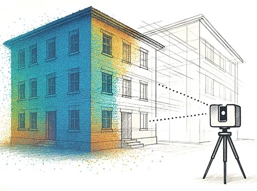
We create GEODATA for property design and management
At MAP.ING we work with the most modern 3D laser scanning and interior photography equipment on the market.
We offer a fully web-based service tailored to our clients' needs. The products we offer:
Web-based virtual walkthrough with dimensions
Floor plans, sections, facade plans
3D information models
3D Model for Architectural Heritage Restoration

ABOUT US
MAP.ING comes from the English term for mapping. Our team consists of specialists with experience in geoinformatics. We are enthusiasts about open-source software and open data.
In 2020, MAP.ING won Copernicus Masters with its water management project AquaLab, which is funded by the German Space Agency - DLR.
In 2023, our team participated in the Space Hubs Network accelerator to improve its business and managerial skills. In the program, we worked with foreign mentors who are leading specialists in economics and digital agriculture in Europe.
MAP.ING participated with a project proposal in the Autodesk Technology Impact program for small and startup businesses.
The project was accepted successfully and we received a donation for software products from the AEC range - Architecture, Engineering and Construction.
We are members of BESCO - The Bulgarian Entrepreneurial Association
We are members of the Bulgarian-Czech Chamber of Commerce
The advantages of working with us
in Bulgaria and abroad
in Bulgaria and abroad